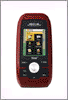
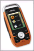
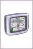
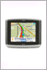
Garmin GPSMAP 640

GPSMAP 640 is the latest dual purpose GPS navigation system from Garmin for both the land and the sea.
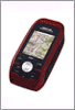
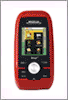
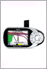
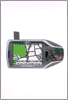
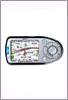
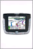
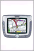
GPSMAP 640 is portable and rugged, and has a waterproof (IPX7) 5.2″ WVGA touchscreen display with 800×480 pixels resolution. It comes preloaded with maps of North America and worldwide shaded relief mapping in addition to detailed U.S. coastal BlueChartg2 charts.
GPSMAP 640 is smart enough to automatically start up in marine mode when placed in its included marine mount. Also with the optional BlueChart g2 Vision technology, the GPSMAP 640 can provide a 3-D "mariner's eye view," for a navigation perspective above the waterline, and a "fish eye view" for an underwater 3D bathymetric contour perspective.
Mariners will also benefit from the auto guidance technology the g2 Vision data card enables that suggests the best navigational route. In addition, photo references give detail aerial views of points of interest (POI) such as ports, marinas, waterways and landmarks.
GPSMAP 640 also has support for XM WX Satellite Weather with the GXM 40 antenna which can display the information directly on the screen. With GXM 40 you'll have access to more than 20 different types of weather attributes, nearly 200 channels of commercial-free music, news, sports talk and entertainment with XM Satellite Radio, and XM NavTraffic to avoid traffic.
GPSMAP 640 will go for $1200 when it first comes out.
Labels: GPS navigation, GPSMAP 640, GXM 40, navigation system, waterproof, XM WX Satellite Weather
posted by HighSpeedSat @ 1:13 AM
0 comments
![]()
![]()